 |
CAMBODIA NATIONAL
LEVEL 1 SURVEY |
 |
3.7 Extrordinary Issues Arising During the Survey
Flooding
Weather is an unpredictable circumstance with potentially significant implications for survey
operations. In Cambodia, the wet season generally starts in May. By August, much of the country may be flooded and may remain so until October when the rains generally begin to abate.
Although environmental conditions during the wet season pose significant difficulties, not to survey during the wet season would be to waste a great deal of time. Therefore, to the extent
possible, deployment planning aimed to keep wet-season deployments out of areas most likely to become seriously flooded.

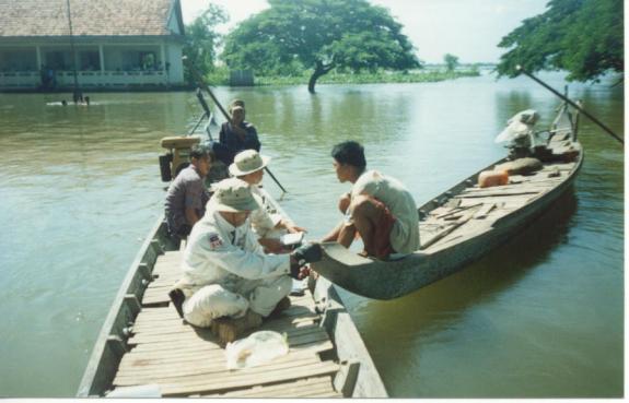
Conditions are normally dry and dusty, but this open water is a good indication of the severity of the flooding faced
by the survey teams.
The rainy season in Cambodia usually causes floods starting in September and continuing until late in the year. The survey extended through two rainy seasons - 2000 and 2001. When the survey first started in Pursat Province in Sept 2000 severe flooding had caused many villagers to evacuate their homes and move to the only dry ground available which was along raised roadways. In the second rainy season, starting in August 2001, the flooding was even more severe. The incidents recorded here and reflected in the surveyors' stories are mainly from the 2001 flood when the survey was taking place in the north east around the Mekong River and in hilly country to the east of the river. It was during this rainy season that the only serious accident occurred during the survey.
In late September 2001, survey operations were underway in the northeast and north-central provinces of the country. Exceptionally high rains had caused uncharacteristically deep and extensive flooding that increased the time it took to get to and from villages in the current operational area, as well as between Phnom Penh HQ and the mobile field offices. Some villages were accessible only by trekking through many kilometers of deep mud or water.

Poor accessibility is not unusual in Cambodia regardless of season as road conditions throughout the country are generally poor. What was extraordinary in this instance, was the large number of stranded villagers who had set up temporary homes along raised main roads making driving even more difficult and dangerous than usual. In addition, it was impossible to survey in villages that were temporarily abandoned due to the flooding. In general, deployment plans were revised so as to survey in less-seriously affected areas immediately and to return to heavily flooded areas once the flooding receded.
In areas of low contamination, it was possible to survey in flooded villages particularly if the village population were congregated in the school house or pagoda seeking refuge from
the water. In late August 2001, survey operations were underway in the northeast provinces of Kracheh, Steung Treng and Rattana Kiri. At that time, the upper reaches of the Mekong River and its tributaries had not yet flooded the surrounding area despite the fact that it was raining most of everyday in the survey area of operations. However, working conditions were becoming extremely difficult.
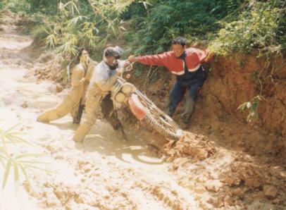
Entrenched in mud, surveyors haul a motorcycle to dry land
Boots and uniforms were never dry. Road accessibility which is difficult and slow under ideal conditions was hampered even further. Surveyors often had to travel in small boats on very fast moving rivers to reach entire communes of people cut off from the rest of the country. Motorcycles were difficult to drive and trucks virtually impossible to use in areas outside main population centers. Staying in remote villages overnight was unavoidable. In instances, local guides got lost leading surveyors to and from villages.
The field management team considered the options. Teams could continue in the region for the two weeks required to complete operations or redeploy south and return to the region during the dry season to complete the work. Several factors were considered in making the decision:
1. The field office in Rattanak Kiri was located approximately 300 km. from Phnom Penh headquarters in central Cambodia. At best, it was a two-day journey and more often a three-day one to reach the area. Since all areas remaining to be surveyed were even further south than Phnom Penh, a redeployment from and then back to the northwest would represent a considerable time loss.
2. Weekly hydrological reports indicted that water levels in the Mekong River were within the expected range for the time of year and were holding steady or rising only slightly each week. It seemed likely that serious flooding would not occur before the field unit had completed work in the area.
3. Weather and flooding conditions were generally poor in other as yet unsurveyed areas of the country. Field managers were in the midst of deciding on a contingency plan in light of unexpectedly poor conditions in the upcoming deployment area.
It was decided to remain in the current area of operations until it was completely surveyed or for as long as possible in light of environmental conditions. This seemed a better option than re-deploying the entire field unit from and back to this extremely difficult to access region at a later date.
As the teams were completing the survey in the last few villages within the deployment area and were preparing to move south, sudden heavy rains in Laos caused an abrupt rise in water levels in north east Cambodia. The Mekong River overflowed its banks. Long stretches of the only road out of the region were completely submerged. The field unit was cut off. It would be weeks before the trucks could again use the road.
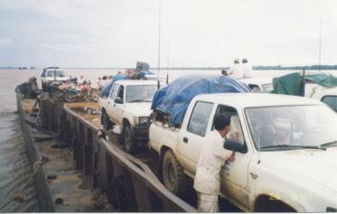
Moving the project to Kampong Cham at the height of the flooding.
A decision was undertaken to rent a barge on which the trucks and other equipment and supplies would travel down river to Kompong Cham. From there it was possible to travel by road to the new field office in Kompong Spue Province. Normally, much of Kompong Spue would be too flooded to survey at this time of year but once again the floods proved unpredictable. Consequently, until November when the rains finally stopped, pre-deployment reconnaissance was significantly intensified in order to choose areas where operations were least likely to be affected by flooding. Teams, that under normal conditions worked relatively close to one another, had to be dispersed in order to take advantage of clusters of villages that were still able to be surveyed. On several occasions it appeared as if operations would have to stop completely until the floods receded but in the end the changing nature of the flooding always afforded the surveyors an area able to be visited.
Surveyor Accident
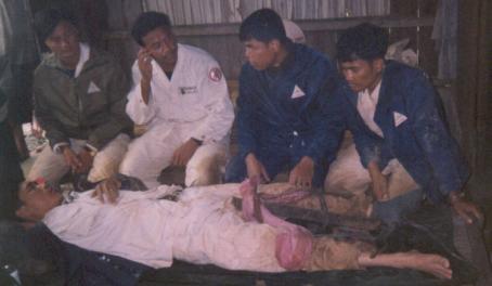
Liv Ling and other surveyors awaiting transport to the hospital.
Two Villages Not Surveyed
In total, surveyors visited 13,907 of 13,909 known villages. The reasons for not doing the survey in the two villages that remain to be surveyed are outlined below.
1. Ampil Village, Memot District, Kompong Cham Province
Surveyors arrived and prepared in the usual manner to conduct the survey. However, once the purpose of their visit was made clear they were asked to leave. Although GPS readings indicated that the village was within the territorial bounds of the Kingdom of Cambodia, according to local officials and villagers, the village is under the administration of Vietnam. The village chief signed a memorandum indicating this to be the case.
2. Mondul Kiri
Mondul Kiri is a province of relatively few people living in villages separated by large tracts of jungle. Some villages are accessible only by foot on rarely used paths. At the outset of the first deployment to this province, little was known about the mine/UXO situation. As in other areas where there was little pre-existing information, accessibility in relation to surveyor safety was a particular concern. Despite the procedures in place, final decisions as to what is or is not safe access always reflected the surveyor's assessment of the situation. This was possible as all but a few surveyors were trained and experienced deminers – a fact that was of considerable significance with regard to questions of safe access.
The first deployment to Mondul Kiri was in June 2001 – early in the rainy season. At that time the teams visited 82 of the 94 villages identified (5 new villages were added to those identified by the gazeteer). The remaining villages were not visited because even a small amount of rain was sufficient to obliterate paths and trails.

In instances, surveyors got lost following guides and were forced to abandon their motorbikes and hike and/or spend the night in the jungle. Rather than take chances, it was decided to suspend the deployment for the time being and to reassess accessibility of the remaining villages during the dry season when conditions would be different.
In April, 2002, Team 4 returned to Mondul Kiri to reassess the situation. They surveyed a
total of 19 additional villages – two more than had been previously identified.
Unfortunately, one village was deemed too remote to safely access as it required more than a day of trekking on foot through relatively unknown jungle in a situation of poor communications.